Geospatial Data for Wind Energy Project
Discover how GEOVIA geospatial insights empower you to visualize, plan, and optimize your wind energy projects with precision and confidence.
What is GIS Used for in Wind Energy Project?
Wind farm projects rely on Geographic Information Systems (GIS) to analyze spatial data at every stage of the lifecycle, from site identification to operation. It helps identify optimal sites by evaluating factors like wind speeds, terrain and environmental constraints. GIS integrates data to assess performance, environmental impact and risks, enabling informed, data-driven decisions that improve the efficiency and sustainability of wind energy projects.
The Role of Geospatial Data for Wind Energy Project Planning
In a tender process, there are numerous requirements to fulfill. GEOVIA Urban Planning solutions helps consolidate and visualize these requirements, providing a comprehensive overview that enables you to build your tender proposal with greater confidence.
In every infrastructure project, stakeholders must identify and evaluate location constraints and opportunities early and accurately to ensure feasibility and success. Leveraging geospatial data in project planning helps assess the impact of the project's immediate environment, enhancing its sustainability.
Key Benefits of Geospatial Solutions for Data Management in Wind Energy Projects
Optimized Site Selection
Pinpointing high-wind areas and evaluating terrain for optimal turbine placement.
Environmental Impact Assessment
Mapping wildlife habitats, noise levels and community proximity to minimize ecological disruptions.
Risk Mitigation
Identifying terrain stability, weather patterns and offshore obstacles to avoid operational risks.
Enhanced Decision-Making
Visualizing wind conditions and topography to make data-driven decisions on turbine layout and design.
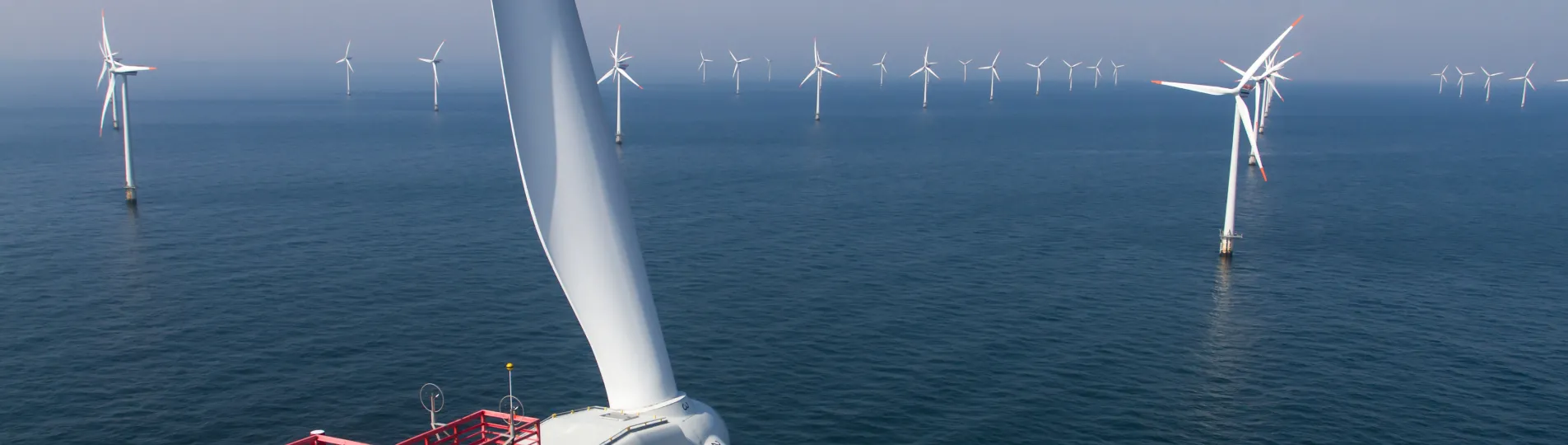
GEOVIA Urban Planning Solutions for Offshore Wind Farm Project
Wind farms are large-scale projects that require significant space while needing to stay within a reasonable distance from residential areas to minimize energy loss. Citizen opinion is therefore crucial. GEOVIA provides the geospatial virtual twin that integrates all 3D modeling of wind turbines, allowing for construction planning and immersive visualization. From different viewpoints, including homes, GEOVIA provides a concrete assessment of their visual impact on the landscape.
Improve Your Teams Performance and Reduce Mistakes with the 3DEXPERIENCE Platform
The strength of GEOVIA Urban Planning solutions comes from their seamless integration with the 3DEXPERIENCE platform. This secure, cloud-based platform empowers you to centralize all your technical documents in one repository, accessible worldwide with just an internet connection.
A role-based system ensures that each team member accesses the relevant information based on their needs. This enables you to work with your entire team from a single virtual space while safeguarding intellectual property and promoting effective collaboration.
The 3DEXPERIENCE platform allows you to invite external stakeholders and members of the tender consortium, like a partnering company, to contribute to your project proposal. You can also grant access to end clients, enabling them to easily track the project's progress through a simplified view and building trust through transparency and partnership.
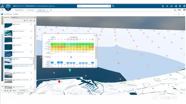
Visualize Projects in Their Full Context
GEOVIA Urban Planning solutions provides the tools to contextualize your project and improve decision-making by creating a georeferenced virtual twin of your project and its surroundings. Using both 2D and 3D data, this immersive environment enables the visualization of the site and consolidates various data, such as wreckage locations and tidal patterns.
Geospatial Data for Wind Energy FAQs
Also Discover
Transform how energy infrastructure is planned using GEOVIA's geospatial technology and team collaboration to improve sustainability.
Rethink innovation to create a sustainable future for Infrastructure, energy and materials.
Learn What GEOVIA Can Do for You
Speak with a GEOVIA expert to learn how our solutions enable seamless collaboration and sustainable innovation at organizations of every size.
Get Started
Courses and classes are available for students, academia, professionals and companies. Find the right GEOVIA training for you.
Get Help
Find information on software & hardware certification, software downloads, user documentation, support contact and services offering