
Urban Planning
Shaping the 21st Century Urban Landscapes
Explore, Design and Monitor the Urban Landscape
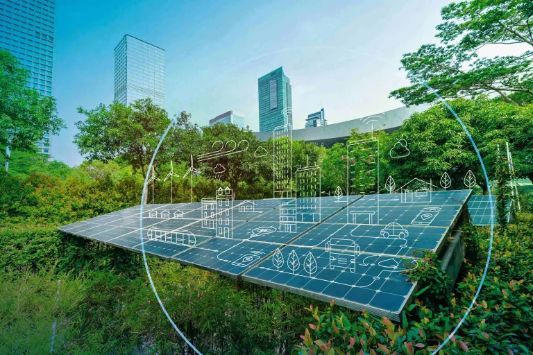
GEOVIA Urban Planning provides city designers, planners, and architects with the tools to create a virtual twin, a 3D copy of an existing urban landscape, using all available data, including geological, topographical, demographic, and transportation information. From there, they can simulate how urban projects could evolve over time and in various circumstances.
Finally, because these tools are united on the 3DEXPERIENCE platform, all stakeholders in city departments and the overall urban environment can (subject to custom-built access rules) easily see and share views of the virtual twin, leading to a greater understanding of the reasons behind, and implications of, city planning decisions.
GEOVIA Urban Planning Key Benefits
More Knowledge, Less Risk
Eliminates uncertainty by visualizing all layers of a complex urban environment.
Improved Geospatial Insights
Uses data engineering to generate better insights from geospatial data.
Better Decision Making
Enables cities to build a common data referential — a single source of truth.
GEOVIA Urban Planning software products are packaged as Roles to get you up to speed faster and work more efficiently with all needed applications available at your fingertips. Select a package that corresponds to your role in an organization.
GEOVIA Urban Planning FAQ
Examples of Urban Planning:
- Streetscapes: Designing road layouts, sidewalks, and visual elements along streets to enhance functionality and aesthetics.
- Public Parks: Creating recreational areas that offer greenery, relaxation, and leisure activities for the community.
- Green Spaces: Designating areas within urban settings for gardens, trees, and natural habitats to promote environmental health.
- Transportation Systems: Planning efficient networks of roads, public transit, and pedestrian pathways to ensure smooth mobility.
- Zoning Regulations: Implementing rules that regulate land use, ensuring compatible activities and preserving community character.
The idea of sustainable urban planning centers around the creation of cities and communities designed to be enduringly environmentally, socially, and economically viable. This approach takes into account the multifaceted dimensions of development – environmental, economic, and social – with the aim of establishing cities capable of withstanding the impacts of climate change, population expansion, and various other environmental and economic complexities.
Urban planning constitutes a intricate procedure encompassing a diverse array of components. This process entails the determination of a city or town's layout and its intended utilization. The fundamental principles guiding urban planning encompass seven key concepts:
- Land Use
- Transportation
- Infrastructure
- Environment
- Economic Development
- Social Equity
- Governance
These core notions establish the bedrock of urban planning, playing a vital role in shaping habitable and environmentally viable cities.
Urban planning revolves around the notion of location and space. Whether it entails comprehending the existing configuration of a particular area or formulating a vision for the city's future progress, GIS (Geographic Information System) emerges as an indispensable tool. This comprehensive system enables urban planners to scrutinize a myriad of data within a singular framework, encompassing facets such as the city's current status, land-use regulations, environmental concerns, and community sentiments.
In essence, GIS is a linchpin for urban planners, enhancing their ability to orchestrate development projects while considering spatial factors, fostering sustainability, and ensuring the overall betterment of urban environments
Urban planners commonly use Geographic Information Systems (GIS) as an integral tool in their work. GIS is a powerful technology that helps urban planners gather, analyze, and visualize spatial data related to cities and urban areas. Here's how and in which sectors planners use GIS:
- Spatial Analysis
- Zoning and Land Use Planning
- Infrastructure Planning
- Environmental Impact Assessment
- Transportation Planning
- Demographic Analysis
- Public Engagement
- Disaster Preparedness and Response
- GIS Software: Vital for mapping and analyzing spatial data, GIS software aids urban planners in visualizing and comprehending information related to land use, transportation networks, demographics, and environmental factors.
- CAD Software: Used for crafting intricate architectural and engineering drawings, CAD software assists planners in designing infrastructure, buildings, and public spaces.
- Simulation and Modeling Tools: Planners employ simulation and modeling software to create scenarios for urban development, enabling predictions about the effects of proposed changes on traffic flow, energy consumption, and urban systems.
- Data Analytics and Big Data: Leveraged by urban planners, data analytics and big data tools analyze extensive datasets, extracting insights to guide data-driven decisions regarding transportation, housing, and infrastructure projects.
- 3D Visualization Software: These tools enable planners to construct virtual models of urban projects, allowing stakeholders to visualize the appearance and functionality of proposed developments.
- Remote Sensing Technologies: Satellite imagery and aerial drones provide planners with up-to-date, high-resolution data for tasks like land-use mapping, environmental monitoring, and disaster response.
- Transportation Planning Software: Specialized software assists transportation planners in analyzing traffic flow, optimizing public transit systems, and designing efficient transportation networks.
- Environmental Assessment Tools: Planners use environmental assessment software to evaluate the impact of development projects on the environment, ensuring compliance with regulations and sustainability goals.
- Public Engagement Platforms: Digital platforms and social media facilitate community engagement, input gathering, and public participation in the planning process.
- Sustainability and Energy Modeling: Software for sustainability analysis and energy modeling assess the environmental and energy efficiency aspects of urban designs and infrastructure projects.
- Real Estate and Market Analysis Software: Urban planners employ these tools to understand market trends, property values, and economic factors that influence development decisions.
| Scope | Urban Planning | Urban Design |
|---|---|---|
| Definition | Involves comprehensive, long-term management of urban areas, addressing policies, regulations, and strategies for guiding city and regional growth. Factors considered include land use, transportation, infrastructure, zoning, and social/economic elements to create sustainable and functional urban environments. | Focuses on the physical and aesthetic aspects of urban spaces, working on the arrangement of buildings, streets, public areas, and overall layout to improve functionality, aesthetics, and quality of life within specific areas of the city. |
Goals
| The primary goal of urban planning is to create sustainable, equitable, and efficient urban environments. Planners strive to balance various aspects such as economic development, environmental sustainability, social equity, and public health. | Urban design aims to enhance the physical and visual aspects of urban spaces. Designers work to create attractive, pedestrian-friendly neighborhoods and public spaces while considering aesthetics, architectural coherence, and human-scale interactions. |
| Professionals | Urban planners typically have backgrounds in urban studies, geography, or public policy. They often work for government agencies, consulting firms, or nonprofit organizations. | Urban designers often have backgrounds in architecture, landscape architecture, or urban design itself. They focus on the physical design and aesthetics of urban spaces and may work for architecture firms, design studios, or as independent consultants. |
In summary, urban planning encompasses a wide range of factors and operates on a larger scale to shape the overall development of cities, while urban design concentrates on the physical design and appearance of specific urban areas to improve their functionality and visual appeal. Both fields collaborate to create well-balanced, livable urban environments.
Also Discover

How can sustainable cities thrive as urbanization increases?
Virtual twin experiences empower stakeholders shaping the world’s cities – from construction firms to urban leaders – to explore unlimited scenarios to optimize human experience and protect our planet. And because the twins are built on scientific principals and data, the most sustainable actions can be taken in service of and in consultation with everyday citizens: from optimizing the layout of a single building to determining the best routes for public transportation.
Delivering the Power of Virtual Twin for Architecture, Buildings, Infrastructure, and Urban Planning Projects

Mine Planning Solutions to Identify Earth's True Potential
Sustainable Solutions for Earth's Natural Resources

Geology Solutions for Mining and Beyond
Learn What GEOVIA Can Do for You
Speak with a GEOVIA expert to learn how our solutions enable seamless collaboration and sustainable innovation at organizations of every size.
Get Started
Courses and classes are available for students, academia, professionals and companies. Find the right GEOVIA training for you.
Get Help
Find information on software & hardware certification, software downloads, user documentation, support contact and services offering